back up to https://onebubble.earth
How far is it?
Sunday, March 15, 2015 - 11:24
A simple and reasonable question to ask; so surely I know the answer, right? Well...kind of. In fact, when I get asked this question I usually go rather vague. Here is an attempt at explaining why.
Theoretical shortest distance
The theoretical point to point distance (to all intents and purposes) would assume that you never stop and take a direct crow flies route, cutting ALL corners. For a whole host of reasons such a route isn't possible (for any craft). The distance, according to a quick Google Earth path, would be 1658 miles.
That sounds a long way already, but now let's turn theory into practice.
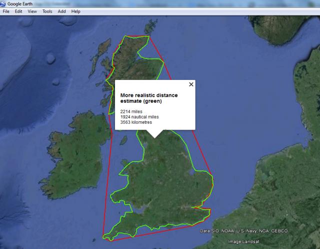
Shortest distance with a reality check
- Every sailing day will start - and end - on land, so I'll be mostly staying close enough to land to make stopping practical. Forget long straight lines - my route will be more akin to a vacuum bagged outline hug of Britain's 2D footprint.
- All detours to come ashore and get back on track afterwards are additional miles.
- For safety reasons I will often stay closer to the coast than an optimum route would take me, adding additional miles.
- When the wind is 'on the nose' I'll be tacking upwind rather than sailing a straight line (for the non-sailors reading this - you can't sail straight into the wind; progress is made by zig-zagging at an angle of about 45º to the wind). With good conditions, upwind sailing could bring me 2 miles towards my target for every 3 miles sailed (the distance covered over ground being approximately 50% greater than the distance acheived towards target).
- With the wind from coming from behind (downwind sailing) I'll also zig-zag, although typically with much more open (broader angles) so the additional distance is less.
- An additional variable is the route sailed up the Irish sea.
The second Google Earth plot assumes a more reasonable route (although is still very approximate), and comes out at 2214 miles. It didn't escape my attention that this is substantially more that the "1800 miles on a 12ft board" strapline on the cover of the book that Tim Batstone wrote after completing his original circumnavigation feat. The reason for this is that the Batstone figure is in nautical miles. So my Google Earth path (2214 miles or 1924 nautical miles) isn't so far off after all.
If miles don't do it for you, that comes out at 3563 kilometres.
Actual distances
These figures don't take into account any zig-zagging or detours, so distance to be sailed is substantially more.
Gulp.